
Tornadoes are a significant weather phenomenon in the United States, particularly during tornado season, which typically runs from spring to early summer.
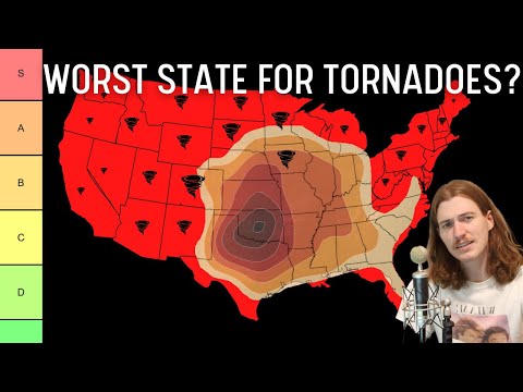
While many states see tornado activity, Texas ranks as the number one state for tornadoes, experiencing the highest average number annually. This state, along with others in the infamous Tornado Alley, witnesses the most frequent and severe tornadoes due to its unique geography and climate conditions.

Tornado Alley, which stretches from Central Texas to South Dakota, is known for its intense storm systems that can spawn multiple tornadoes in a single day. Residents and meteorologists closely monitor these storms, as they bring considerable risks to life and property.
With a long history of tornadoes, understanding the patterns and behaviors of these storms is essential for safety and disaster preparedness.
The information on tornado activity is critical for those living in affected areas. Whether one is a storm chaser or simply a curious reader, staying informed about tornadoes and their occurrences can make a difference.
For insightful articles on atmospheric phenomena, resources are available that dive deeper into understanding these powerful storms.
Geography of Tornadoes

Tornadoes are influenced by geographic features that shape their formation and frequency. The two main regions in the United States known for tornado activity are Tornado Alley and Dixie Alley.
Additionally, the Gulf Coast plays a significant role in the weather patterns that contribute to tornado generation.
Tornado Alley Overview
Tornado Alley primarily covers the Great Plains stretching through states like Texas, Oklahoma, and parts of Kansas and Nebraska. This region is known for its flat landscapes that allow warm, moist air from the Gulf of Mexico to meet cooler, dry air from Canada.
The conditions are ideal for the development of severe thunderstorms, which can lead to tornadoes. Texas leads Tornado Alley with an average of about 155 tornadoes annually. Oklahoma closely follows with a high frequency of tornado occurrences, often ranking second.
Dixie Alley Characteristics
Dixie Alley encompasses parts of the Southeastern United States, including states such as Mississippi, Alabama, and Louisiana. Unlike Tornado Alley, this region experiences tornadoes mainly in the spring and fall, driven by unique weather patterns.
The Mississippi Valley’s humid subtropical climate leads to a different type of tornado development. Tornadoes here can be particularly dangerous due to their potential to form after dark, making them less visible and harder to predict. This area has a high incidence of strong tornadoes rated EF3 and above, which can cause significant damage.
The Impact of the Gulf Coast
The Gulf Coast has a vital influence on tornado activity across the southeastern states. Warm, moist air from the Gulf of Mexico fuels storms, creating conditions favorable for tornado formation.
As this air moves inland, it interacts with cooler air coming from the north, leading to severe weather.
During late spring and early summer, the Gulf Coast can see a spike in tornado occurrences. This area contributes to the severe weather outbreaks that impact regions across Dixie Alley. The combination of geographical features and atmospheric conditions makes the Gulf Coast a crucial factor in understanding tornado geography.
More insights can be found about regional weather phenomena.
Tornado Metrics and Records
Tornado metrics and records provide crucial insights into the intensity and frequency of tornadoes in the United States. Data collected over the years helps to understand the patterns and risks associated with these severe weather events.
Historical Data and Statistics
The National Oceanic and Atmospheric Administration (NOAA) plays a vital role in collecting tornado data. Since the early 1950s, the NOAA’s National Centers for Environmental Information (NCEI) has documented tornado occurrences.
Recent statistics reveal that the states with the highest number of tornadoes include Texas, Alabama, and Florida. Typically, tornadoes are categorized by their Enhanced Fujita (EF) Scale ratings, which range from EF0 to EF5. An EF0 tornado produces minor damage, while an EF5 tornado, the most severe, can cause catastrophic destruction.
In recent decades, annual tornado events have varied significantly, often based on geographic and climatic conditions. For instance, the April 2011 tornado outbreak resulted in over 300 recorded tornadoes in just one month, showcasing the extreme nature of these events.
NOAA’s Role in Tornado Analysis
NOAA leads the charge in tornado research and analysis. They maintain the Storm Events Database, which logs tornado frequency, intensity, and destructive potential across the country.
This resource is invaluable for scientists and emergency responders alike.
Every tornado documented in this database is critical in refining predictive models. Understanding past tornado behavior enables better forecasting and preparedness strategies.
NOAA’s rigorous data collection supports public safety efforts, informing communities of potential risks and preparedness.
The Science of Measuring Tornadoes
Measuring tornadoes involves several scientific techniques.
The EF Scale is the most widely used system to classify tornado intensity based on damage. An EF1 tornado has wind speeds between 86-110 mph, while an EF4 or EF5 tornado can exceed 200 mph.
Meteorologists utilize Doppler radar to track tornado formation and movement.
This technology allows for real-time monitoring, providing vital information to warn communities in harm’s way.
Field surveys conducted after tornado events help confirm the EF ratings.
Inspecting damage to structures and vegetation aids in understanding the tornado’s strength.
Combining historical data with modern technology makes it possible to improve safety measures and community awareness, ultimately saving lives during these extreme weather events.